The Northwest Passage has been a subject of fascination for explorers, sailors, and cartographers for centuries. The route, which connects the Atlantic and Pacific Oceans through the Arctic Archipelago of Canada, has been both a source of intrigue and a challenge due to the harsh environmental conditions. In this article, we will explore the NW Passage Map, examining 10 key features that every explorer should know. Whether you’re a seasoned adventurer or someone curious about the history and geography of the region, understanding these features will enhance your knowledge of one of the most significant maritime routes in history.
The Geographical Overview of the NW Passage
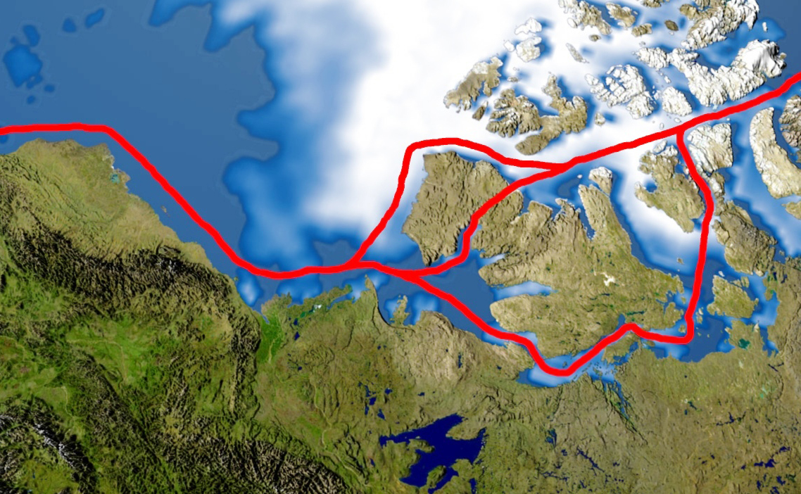
The NW Passage Map outlines a vast stretch of water that traverses the Arctic Archipelago of Canada. The route itself is complex, consisting of a series of straits and channels interspersed with islands, glaciers, and ice floes. The map typically highlights two major routes: the southern route through the Canadian Archipelago and the northern route which runs closer to the Arctic ice cap. Depending on ice conditions, the passage can either be passable or impassable, affecting travel through the region.
The Impact of Climate Change on the Passage
Climate change has dramatically impacted the NW Passage Map by altering ice coverage and seasonal navigation patterns. As temperatures rise, the ice in the Arctic region has begun to melt more rapidly, leading to longer periods when the passage is navigable. This has opened new possibilities for shipping routes, but it has also raised concerns regarding the environmental consequences and the safety of increased human activity in the region. Updated NW Passage Maps often reflect these changes by showing shifting ice margins and new open water routes.
Key Islands Along the NW Passage
The NW Passage Map is dotted with a range of islands that serve as waypoints or navigational markers for explorers. Some of the most notable islands include Banks Island, Victoria Island, and Ellesmere Island. These islands are part of Canada’s Arctic Archipelago and are often shown in detail on the map. Understanding the geographical layout of these islands is essential for explorers planning a journey through the passage. Many of these islands are remote and sparsely inhabited, often serving as research outposts or historical landmarks.
The Historical Significance of the NW Passage
The quest to find a navigable NW Passage Map has a rich history, dating back to the early 15th century. For centuries, explorers sought a direct route to Asia through the Arctic, believing that it would open new trade routes. The most famous expeditions, such as those led by Sir John Franklin, were fraught with peril, leading to loss of life and numerous failed attempts. These historic voyages are marked on Maps, highlighting the locations where explorers met with success and failure, providing valuable insights into the passage’s history.
The Role of Modern Technology in Mapping the NW Passage
In the past, creating an accurate NW Passage Map was a painstaking process, relying heavily on traditional navigation tools and direct exploration. Today, modern technology such as satellite imaging, GPS, and ice-tracking software allows cartographers to produce highly detailed and accurate maps of the region. These tools also enable explorers to plan safer and more efficient routes through the passage, taking into account the constantly changing ice conditions and weather patterns that have historically posed significant challenges.
Ice Navigation and Seasonal Variations
One of the defining features of the NW Passage Map is its depiction of ice conditions. The Arctic ice cap fluctuates in size and density throughout the year, with thick ice dominating in winter and thinner, more navigable ice forming in summer. The passage’s navigability depends on these seasonal variations. During the warmer months, the ice recedes, creating a window of opportunity for vessels to pass through. This is reflected in updated Maps, which show the extent of ice coverage during different seasons and years.
Wildlife and Ecosystems in the NW Passage
The Arctic waters surrounding the NW Passage Map are home to a unique array of wildlife and ecosystems. From polar bears to walruses and seals, the region is teeming with life. The map often includes indicators of important wildlife habitats, making it a valuable tool for explorers who want to protect the delicate environment. Researchers also use these maps to track changes in wildlife populations as they respond to the shifts in climate and ice conditions. These ecosystems are fragile, and understanding their locations is crucial for both conservation and navigation.
Indigenous Peoples and Cultural Heritage
The NW Passage Map is not only a tool for navigation; it also holds cultural and historical significance for the indigenous peoples who have lived in the Arctic for millennia. Groups such as the Inuit and the Chukchi have navigated the icy waters long before modern explorers, using traditional knowledge and oral history to guide them. Many areas along the Map are home to indigenous communities, whose way of life is closely tied to the region’s geography and environment. Including these cultural markers on the map ensures that explorers respect and acknowledge the heritage of the people who have called these lands home for generations.
Modern Shipping Routes and Economic Opportunities
The NW Passage Map has evolved beyond a simple explorer’s tool; it now plays a significant role in global shipping. With the ice melting, shipping companies are increasingly looking to the passage as a shortcut between the Atlantic and Pacific Oceans. This is particularly significant for trade between Europe and Asia, as it can reduce shipping times and costs by avoiding the traditional route around the Cape of Good Hope or through the Suez Canal. Updated maps highlight these new shipping lanes and mark out the safest routes, contributing to the growth of global trade in the region.
Challenges and Risks of Navigating the Passage
Despite the allure of the NW Passage Map for modern shipping and exploration, navigating the passage remains fraught with challenges and risks. The region’s unpredictable ice patterns, extreme weather conditions, and remoteness can all pose significant dangers. In addition, the lack of infrastructure and emergency services makes the area particularly hazardous. Even with the most advanced technology, the passage can be dangerous, and explorers need to be well-prepared. Updated Maps often include risk assessments and cautionary notes for those planning a journey through the Arctic.
Conclusion
The NW Passage Map is more than just a navigational tool—it is a symbol of the human spirit of exploration and the changing landscape of our planet. From its historical significance to its role in modern shipping and environmental changes, understanding the features of the passage is crucial for anyone wishing to explore or study the Arctic. Whether you’re an adventurer, a researcher, or just an interested observer, the Map provides valuable insights into one of the most mysterious and challenging regions of the world.
FAQs
Q1. What is the Northwest Passage?
The Northwest Passage is a sea route that connects the Atlantic and Pacific Oceans through the Arctic Archipelago. It has been a coveted path for explorers for centuries.
Q2. How has climate change affected the Northwest Passage?
Climate change has led to a reduction in ice coverage, making the passage more navigable during summer months and opening new opportunities for shipping.
Q3. Why is the Northwest Passage historically significant?
The passage has been sought after for centuries as a shortcut for trade between Europe and Asia. Many famous explorers, including Sir John Franklin, attempted to navigate it.
Q4. How does modern technology help in navigating the Northwest Passage?
Satellite imaging, GPS, and ice-tracking software help create accurate Maps and allow for better planning and safer exploration.
Q5. What wildlife can be found around the Northwest Passage?
The Arctic waters around the NW Passage are home to diverse species like polar bears, seals, walruses, and various marine birds, all of which are impacted by environmental changes.
Also read: Cape Horn on Map: 10 Stunning Locations You Must Explore


