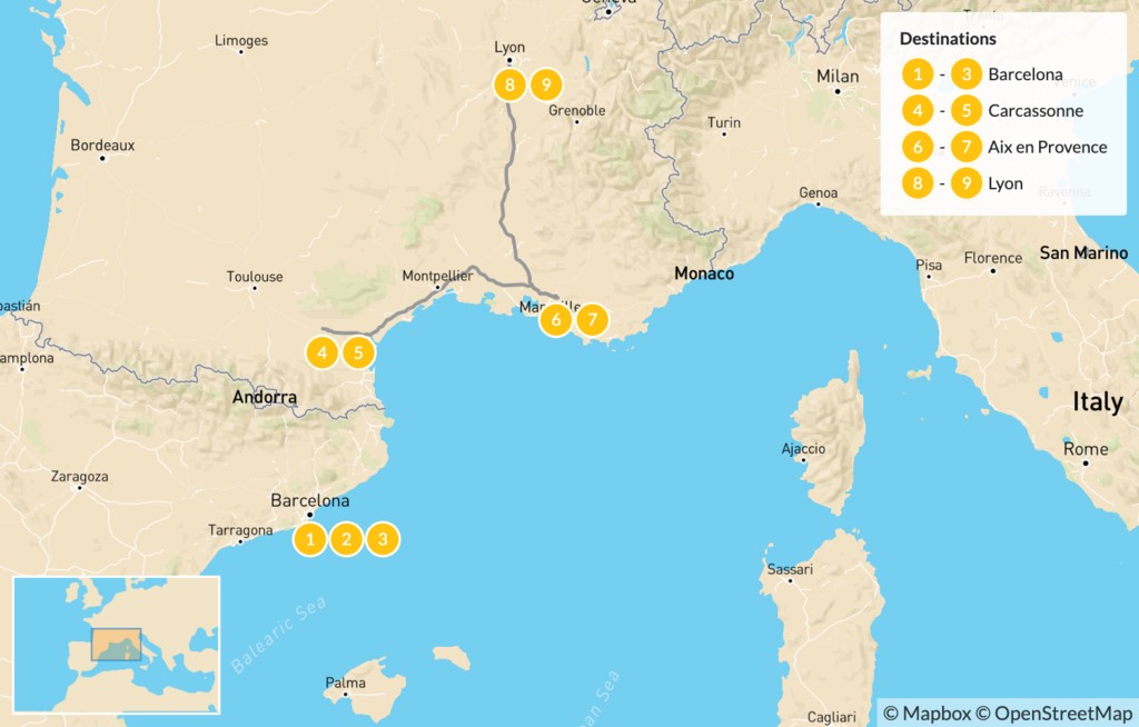
Looking for a detailed and informative map of France and Spain? Whether you’re a student studying geography, a traveler planning a European road trip, or simply curious about the layout of Western Europe, understanding the map of France and Spain gives you insight into their borders, regions, major cities, and must-see landmarks.
This guide provides an overview of the geography, bordering countries, key destinations, and how to use the map of France and Spain for travel, education, or planning purposes.
Map of France and Spain: Overview
France and Spain are two of Europe’s largest and most visited countries, sharing a 505 km (314 mi) land border that runs through the Pyrenees Mountains.
Key Geographic Facts:
| Feature | France | Spain |
| Capital City | Paris | Madrid |
| Area (km²) | ~551,695 | ~505,990 |
| Population (2023) | ~67 million | ~48 million |
| Shared Border | Pyrenees Mountains | Pyrenees Mountains |
| Shared Coastlines | Atlantic Ocean & Mediterranean | Atlantic Ocean & Mediterranean |
A map of France and Spain will often highlight major transport routes, rail lines, regional divisions, and key cities such as Barcelona, Bordeaux, Lyon, Seville, Marseille, and Bilbao.
How France and Spain Are Positioned on the Map
- France lies to the north of Spain, bordered by Belgium, Luxembourg, Germany, Switzerland, Italy, and the English Channel.
- Spain is in southwestern Europe, bordered by Portugal to the west and France to the northeast.
- The Bay of Biscay lies between the two countries on the west coast.
- Both countries share access to the Mediterranean Sea along their southern and eastern coasts.
Using a Map of France and Spain for Travel
A France–Spain map is essential for anyone planning a road trip, train journey, or multi-city European tour.
Key Travel Routes:
- High-Speed Rail (TGV/AVE): Paris to Barcelona in ~6.5 hours
- Major Highways: A9/AP-7 corridor connects Montpellier to Barcelona
- Scenic Drives: Drive from Bordeaux through the Basque Country into northern Spain
- Airports on the Route: Paris CDG, Toulouse, Barcelona-El Prat, Madrid Barajas
Must-See Cities on the Map:
- France: Paris, Bordeaux, Toulouse, Lyon, Marseille
- Spain: Barcelona, Zaragoza, Bilbao, Madrid, Valencia, Seville
Tip: Use Google Maps or offline GPS apps to navigate rural regions or explore the Pyrenees, which serve as a natural border.
Natural Borders & Regions on the Map
- The Pyrenees Mountains form the natural border between France and Spain, with notable border towns like Biarritz, Saint-Jean-Pied-de-Port, and La Seu d’Urgell.
- The region of Catalonia in Spain is directly adjacent to Occitanie in southern France.
- Coastal areas include Costa Brava (Spain) and Côte d’Azur (France), both Mediterranean hotspots.
Downloadable & Interactive Map Resources
- Google Maps – Best for real-time navigation and trip planning
- OpenStreetMap – Open-source, detailed community maps
- National Geographic Atlas – Educational and high-resolution reference
- Printable Maps – Available on educational websites and PDF resources
Looking for a high-resolution physical or digital map of France and Spain? Visit EuroGeographics or download free printable maps from government or tourism portals.
Conclusion
Whether you’re a geography enthusiast, student, or traveler, understanding the map of France and Spain helps unlock the cultural, historical, and natural wonders of Western Europe. From the peaks of the Pyrenees to the sun-drenched beaches of the Mediterranean, this region is as diverse as it is connected — and a good map is the first step to discovering it all.
Start your journey with a map in hand — and let France and Spain lead the way through landscapes, languages, and unforgettable experiences.
FAQs
1. Where is the border between France and Spain?
The two countries are divided by the Pyrenees Mountains, stretching from the Bay of Biscay (Atlantic coast) to the Mediterranean Sea.
2. Are there border controls between France and Spain?
Both countries are part of the Schengen Area, so there are no routine passport checks, although random controls may apply.
3. What are major border towns?
France: Perpignan, Hendaye, Bayonne
Spain: Girona, Irun, Figueres
4. Can I travel by train between France and Spain?
Yes, direct high-speed trains connect Paris, Marseille, and Lyon with Barcelona and Madrid.
5. What natural feature defines much of the border?
The Pyrenees mountain range serves as the primary natural barrier between the two nations.
Also read: Tresco Hotel Scilly Isles: Discover Tranquil Luxury on the Isles of Scilly


Leave a Comment