The Cape of Horn Map is an essential tool for any adventurer or historian aiming to understand the geographical, historical, and cultural importance of Cape Horn. Situated at the southern tip of South America, this prominent landmark serves as a symbolic and literal boundary between the Atlantic and Pacific Oceans. Though many are familiar with its name, few fully comprehend its significance.
The Cape of Horn offers valuable insight into the region, providing information that not only covers the physical geography but also historical events, dangers of the waters, and its role in global trade and exploration. Whether you’re an armchair explorer or planning a journey to this remote location, the Cape of Horn is the key to unlocking the mysteries of one of the world’s most treacherous yet fascinating spots.
The Historical Significance of the Cape of Horn
The Cape of Horn Map holds a rich history that dates back to the 16th century. It was named after the Dutch city of Hoorn, as the first recorded sighting of the cape was by Dutch explorer Willem Schouten in 1616. This marked a significant moment in exploration history, as sailors sought new routes to navigate around South America. For centuries, Cape Horn was a critical passage for maritime trade, as ships traveling between the Atlantic and Pacific Oceans had to pass through these perilous waters. The Cape of Horn Map provides insight into the challenging navigation routes and the risks that sailors faced, including fierce storms, icebergs, and strong currents.
Understanding the Geography of Cape Horn
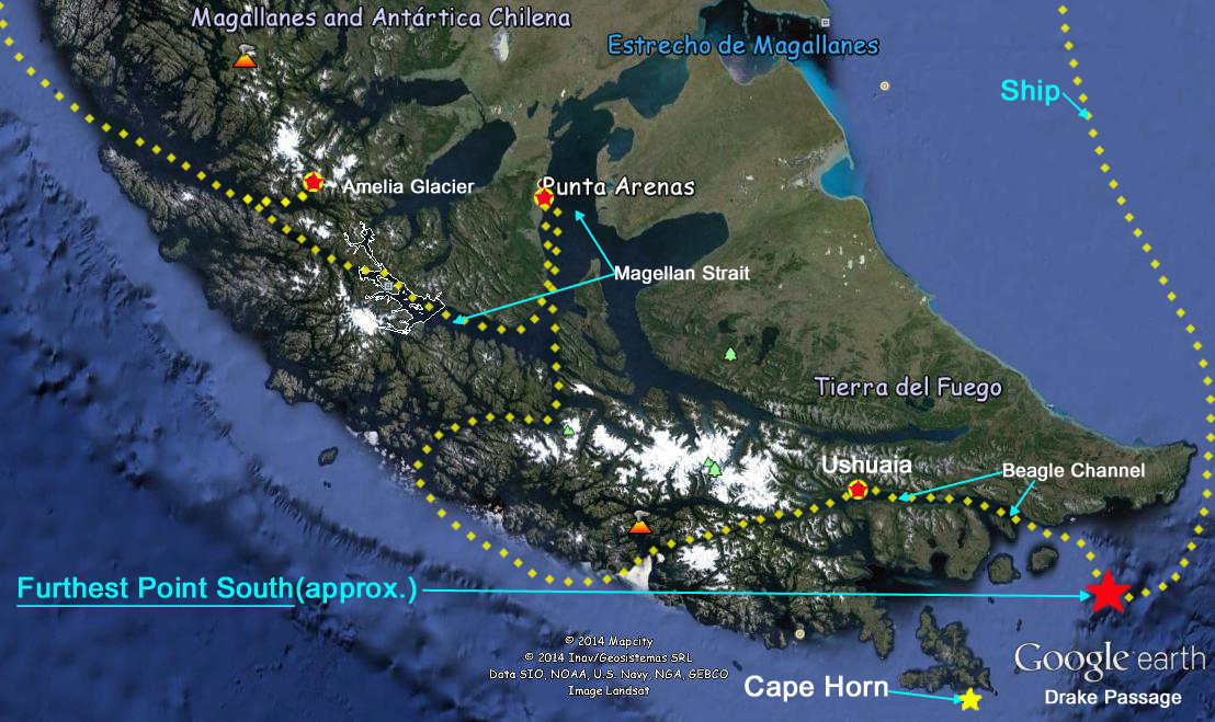
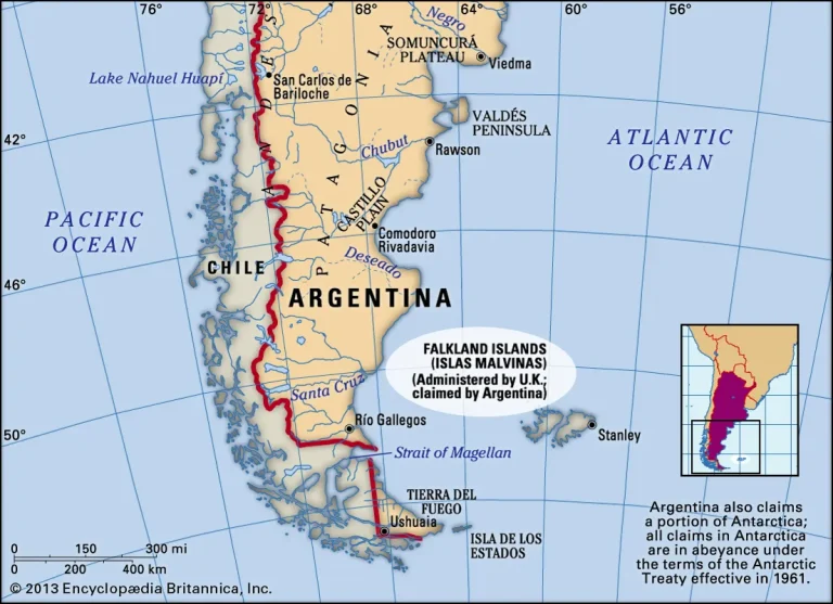
The Cape of Horn Map showcases the physical layout of this iconic cape, highlighting its location at the southernmost tip of the Tierra del Fuego archipelago. The cape marks the point where the Atlantic and Pacific Oceans meet, creating a turbulent and often dangerous stretch of water. It is situated at approximately 55° 58′ S latitude, making it one of the most remote places on Earth. From the map, you can observe how Cape Horn’s jagged cliffs and strong winds create a natural barrier for ships. Understanding this geography is crucial for navigating the waters around Cape Horn, especially when considering the weather and ocean currents that make the region infamous among sailors.
The Challenges of Navigating Cape Horn
Sailors throughout history have faced tremendous challenges when navigating around Cape Horn. The Cape of Horn Map reveals the narrow and treacherous waters surrounding the cape, where unpredictable weather patterns and powerful currents often catch ships off guard. The waters are notorious for strong winds, massive waves, and frequent storms. Navigating this area is no small feat, and only the most experienced sailors could make the journey safely. The Cape of Horn helps modern travelers and sailors understand the dangers posed by the natural elements, giving them a clear picture of what lies ahead.
The Role of Cape Horn in Global Trade
Historically, Cape Horn was a key route for global trade, especially during the 19th century. The Cape of Horn Map illustrates how this passage became crucial for ships traveling between Europe and the Americas, bypassing the need for a long and dangerous journey across the entire continent. Before the Panama Canal was completed, vessels had to sail around Cape Horn to access the Pacific Ocean from the Atlantic. The Cape of Horn highlights how this trade route shaped the economic relationships between countries and played a major role in global commerce during the Age of Sail.
The Impact of Climate on Cape Horn
Climate plays a significant role in shaping the waters surrounding Cape Horn. The Cape of Horn Map gives a clear view of the geographical features that influence the weather patterns in this region. Due to the cold Antarctic currents that meet the warmer waters of the Pacific and Atlantic Oceans, Cape Horn experiences extremely volatile weather. The area is known for its sudden and severe storms, high winds, and low temperatures. Understanding the climate of Cape Horn through the Cape of Horn allows explorers and sailors to plan their trips more effectively, though they must always be prepared for the unpredictable nature of this remote area.
Cape Horn as a Maritime Landmark
For centuries, Cape Horn has served as a significant maritime landmark. The Cape of Horn Map highlights its role in navigation, especially for ships attempting to make the dangerous passage from one ocean to another. Cape Horn was often used by sailors as a landmark for calculating their position at sea. Its presence on the Cape of Horn emphasizes the strategic importance it holds in maritime exploration. Despite the advent of modern navigation technology, Cape Horn remains a symbol of adventure and exploration.
Modern-Day Navigation Around Cape Horn
Although modern technology has made it easier to navigate the seas, Cape Horn still presents challenges for today’s sailors. The Cape of Horn Map allows modern explorers to better understand the terrain and plan their voyages more effectively. With the development of advanced navigation tools like GPS and radar, sailing around Cape Horn has become less dangerous, but the region’s unpredictable weather still poses a risk. The Cape of Horn serves as an essential reference for understanding the key points of interest and potential hazards that remain for ships navigating this legendary route.
The Significance of Cape Horn in Maritime History
The Cape of Horn Map serves as a testament to the historical importance of this region in the development of maritime history. For centuries, sailors braved the dangerous waters around Cape Horn, making it one of the most significant routes for global exploration and trade. Many famous voyages, including those of Sir Francis Drake and Charles Darwin, passed through Cape Horn. The Cape of Horn preserves this rich legacy, showcasing the bravery and skill of sailors who navigated these treacherous waters. It also highlights how Cape Horn has shaped our understanding of the world and our place in it.
Cape Horn as a Tourist Destination
In recent years, Cape Horn has become a popular tourist destination for adventure seekers and nature enthusiasts. The Cape of Horn Map offers an excellent resource for travelers planning to visit this remote location. The region is home to breathtaking landscapes, unique wildlife, and a sense of isolation that draws people from around the world. Visitors can take part in guided tours, cruises, and expeditions to see Cape Horn up close, often stopping at nearby islands and other points of interest along the way. The Cape of Horn provides key information on how to access these attractions and the best times to visit.
The Cultural Legacy of Cape Horn
Cape Horn also holds significant cultural and symbolic value. The Cape of Horn Map illustrates the deep connection between this landmark and the indigenous cultures of the region. For centuries, the native people of Tierra del Fuego have lived in the shadow of Cape Horn, developing their own unique ways of life and maintaining a strong spiritual connection to the land. The map helps us understand the cultural heritage of this area, offering a glimpse into the lives of the indigenous populations and their relationship with the natural world. Cape Horn’s legacy continues to inspire explorers, artists, and storytellers alike.
Conclusion
The Cape of Horn Map is more than just a geographical tool—it’s a gateway to understanding one of the most iconic locations in the world. From its historical significance in maritime trade to its role in modern exploration, the map offers insights into the region’s unique challenges and beauty. By studying the Cape of Horn, explorers and adventurers gain a deeper appreciation for this remote and treacherous cape, while also respecting the legacy it holds in the annals of history. Whether you’re planning a trip or simply interested in learning more about this iconic landmark, the Cape of Horn is the key to unlocking its mysteries.
FAQs
Q1. Why is Cape Horn considered one of the most dangerous places for sailors?
Cape Horn is notorious for its treacherous waters, strong winds, and unpredictable weather. Sailors must navigate through violent storms, massive waves, and freezing temperatures, making it one of the most challenging maritime routes in the world.
Q2. How did Cape Horn get its name?
Cape Horn was named by Dutch explorer Willem Schouten in 1616 after the city of Hoorn in the Netherlands, his birthplace. Schouten was the first recorded European to sail around the cape, opening a new route for maritime trade.
Q3. What wildlife can be found near Cape Horn?
Cape Horn is home to diverse wildlife, including sea lions, whales, albatrosses, and various seabird species. The surrounding waters are rich in marine life, providing a habitat for numerous animals in this remote region.
Q4. Is it possible to visit Cape Horn as a tourist?
Yes, tourists can visit Cape Horn via cruises and expeditions. The region offers stunning views, unique wildlife, and an opportunity to experience one of the most remote places on Earth, although access is limited due to its extreme conditions.
Q5. Why was Cape Horn an important landmark for maritime trade?
Before the construction of the Panama Canal, Cape Horn was a crucial passage for ships traveling between the Atlantic and Pacific Oceans. It allowed merchants to transport goods between Europe and the Americas, making it a vital point in global trade routes.
Also read: Cape Horn on Map: 10 Stunning Locations You Must Explore


Leave a Comment